Uwharrie here: Favorite hiking trails
May 30, 2023
A seasoned hiker shares four favorite trails.
by David Claude Bailey
As a travel writer and former airline-magazine editor, I’ve visited a mountain or two — from Mount Olympus, the seat of Zeus in Greece, to Yellowstone. But all mountains are not created equal. Without getting New Age woo-woo on you, on some of them I get a feeling that transcends the five senses — an eerie, almost spiritual sense of connection.
I felt it first at Delphi, the ancient precinct that was home of the Delphic oracle. I felt it again among the ancient ruins near Ayacucho in Peru. And I feel it every time I go to the Uwharries, a Piedmont mountain range near Asheboro, where the peaks have been worn down from a whopping 20,000 feet to a mere 1,100.
How did that happen? More than 500 million years is one answer. When you tread the trails along Big Island Creek, you are walking on ground that belonged to the ancient landmass of Gondwana, a megacontinent that was once part of modern-day South America and Africa. Somewhere between 460 and 430 million years ago, part of Gondwana broke off and merged into ancient North America, piling up the Uwharrie mountains. Books and websites insist the Uwharries are the oldest mountains in North America, but that’s by no means the case.
“The Rocky Mountains are between about 70 and 35 million years old,” says Kevin Stewart, a UNC Chapel Hill professor in the department of Earth, Marine and Environmental Sciences. “Ancient mountains in the northern midwest stretch back to 2.5 billion years,” he says. And you want really old? Some mountains in South Africa are 6.3 billion years old.
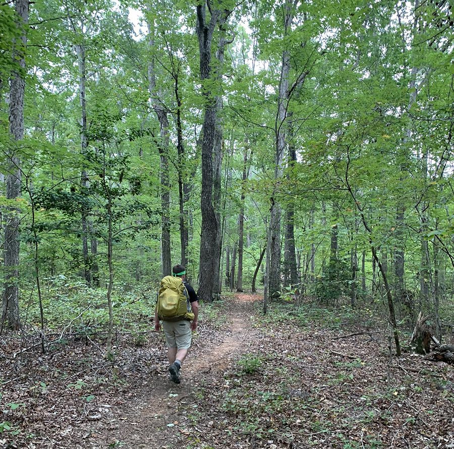
In more recent years, the Uwharries have been the scene of gold mining, timbering, farming, bootlegging and, now, recreation. Running from south to north, the Uwharrie Trail is the longest single-track footpath in central North Carolina at 40 miles in length. Numerous other trails snake through the 52,000-acre National Forest, established in 1961.
This is not a hiking guide, rather a thumbnail of four of my favorite trails. Don Childrey’s comprehensive Uwharries Lakes Region Trail Guide is excellent, along with websites such as alltrails.com and gaiagps.com. Happy trails.
photographs courtesy AllTrails
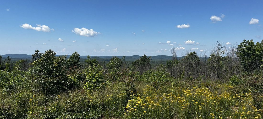
Jumping Off Mountain Trailhead
“Keep on the sunny side, always on the sunny side, keep on the sunny side of life,” the Carter family warbles, and it’s not bad advice. If a sunny walk in the woods is what you want, get yourself to the Jumping Off Rock Trailhead. Cross Flint Hill Road and hike up about a half-mile to the overnight camp cabin. There, you can enjoy a stunning, 360-degree view of the Uwharrie Mountains and have a picnic while reading the camp log. Keep going and you’ll bag an exhilarating 8-mile out-and-back hike to King Mountain, the highest point on the Uwharrie Trail.
If you want a challenge, trek instead right up in the shadow of the appropriately named Dark Mountain. That will put you on a trail trod by murderers, moonshiners and the odd haint or two. Mind you, the switchbacks up Dark Mountain are arduous — you’ll gain 400 feet of elevation in less than a mile. After about three-quarters of a mile, you reach the ridge line. Follow the white blazes on the Uwharrie Trail and you’ll enjoy a glorious 3.9-mile out-and-back jaunt.
But my hiking companion and I have come to see Paint Rock, which we look for along a deserted road to the left. Joe Moffitt, a legendary Uwharrie Trail-blazer, insists in his book, An Afternoon Hike into the Past, that there’s a rock in the woods that still “bleeds” from where a giant man ran his sword through a diminutive Civil War deserter. As far as we can tell, there are numerous Paint Rocks. And maybe that fits Moffitt’s narrative: Three Civil War deserters were murdered near Dark Mountain in 1865. Bootleggers also killed two revenuers at nearby Licker Spring.
We come across some of the largest boulders in the forest. We don’t find the cave where a bootlegger and his family once hid out. But as Moffitt observed, wandering around these shady hills is a bit unnerving: “I always seemed to feel as if someone is watching me.”
Better to get back in the sun and remember what the Carters sang about the sunny side: “It will help us every day, it will brighten all the way, If we’ll keep on the sunny side of life.”
Length: Two hikes are available from the trailhead, an 8-mile out-and-back and a 3.9-mile out-and-back.
Difficulty: Both hikes are challenging with significant
elevation gain.
Don’t miss: The sign in the parking lot that outlines a number of other nearby hikes.
Good to know: The actual Jumping Off Rock is west, heading up Flint Hill Road on the left.
Address: 2015 A Flint Hill Rd., Troy


Left: The Lewis-Thornburg farmhouse. Right: Pia, a German Shepherd, enjoys an off-leash adventure in the Uwharries.
Thornburg Trailhead
Getting 5-year-old Wilder out of his car seat when he’s raring to go is a little like untangling an octopus from a ball of yarn. So as soon as his mom, Cassie, finally gets his feet on the ground, he rips off across the farmyard like the Road Runner pursued by Wile E. Coyote.
Charging full throttle onto the porch of the circa-1850, two-story, apple-green Lewis-Thornburg farmhouse, he’s fascinated by the screen door with its self-closing wheeze and whine, followed by a shuddering slam — for a solid minute.
The National Register of Historic Places’ listing says not to miss the rambling farmhouse’s wide, heart-pine floorboards; the square balusters and molded handrails on the staircase; and the narrow, distinctive beadboard on the walls and ceiling. Wilder, though, is entranced by the mix of soot, feathers and leaves that have spilled out of the chimney onto the circa-1940s linoleum.
“I love holes in the wall,” he says of a crawl-space door left open on the second floor. Spotting a trap door overhead, I boost him up through the cutout. “Spooky,” he says, after peering around into the dim recesses off the attic. It is.
Back outside, we’re finally on the actual trail heading down toward the creek. “Stop!” Wilder says, stooping over. “Sparkles!” The red mud is alive with tiny, shimmering mica bits. Specimens of quartz from tiny to basketball-sized are everywhere, pieces of which he stuffs into his already overloaded pockets. On a little side trail across sage brush beaten down by rabbits, possums and the previous day’s rain, we’re soon surrounded by milkweed pods, which explode into a white flurry that swirls off into the wind, seeding next year’s crop.
We veer off onto another game trail and snake the edge of a field, where blackberry brambles soon occasion a cry of “Ouchy, ouchy, ouchy,” but no tears. “Snack,” comes to the rescue.
“Stop! It’s a gem,” Wilder says, holding up a rare piece of rosy quartz. No room left in his pockets, he casts it aside. “This is Quartz World,” Wilder decides. And he’s absolutely right. It might just be the second most magical place on Earth.
Length: 3.4 miles out and back, with side trails
Difficulty: Moderately challenging with a fair amount of elevation gain
Don’t miss: The rocks strategically placed across the creek near the bridge
Good to know: As Wilder notes, it can be quite muddy.
Address: 3977 Lassiter Mill Rd., Asheboro
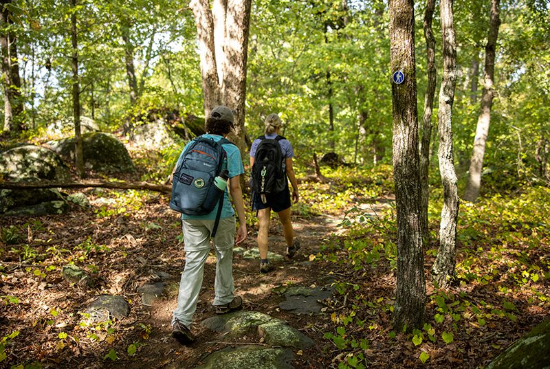
Purgatory Trail, courtesy North Carolina Zoo
Purgatory Trail, North Carolina Zoo
“David, the entrance to the zoo is over there,” my wife, Anne, says as I slide into the North Carolina Zoo’s totally empty Parking Lot A.
“I thought we’d take a short walk in the woods before looking at the animals,” I tell her. “You’re gonna climb a mountain today.”
“The sign says ‘Purgatory Mountain,’” my knee-challenged wife points out.
“Trust me,” I say. She’s heard that before.
“It’s a gentle stroll, suitable for people with mobility issues,” I say pointing to a sign.
And so it is — a wide path paved with very fine gravel soon segues into a little more rugged trail that winds its way up through towering pines and mature hardwoods.
To our left, deep woods and massive boulders the size of baby elephants stretch to the horizon. We breeze past the sign heralding the endangered Schweinitz’s sunflower; past the sign explaining woodland seeps (small pools), which sometimes harbor the rare four-toed salamander; past the sign marking the half-mile point.
At the summit, it’s 950 feet above sea level, only 60 feet shy of the highest point on the Uwharrie Trail. After enjoying the vista, we read all about ghosts, Indians, legendary critters, bootleggers, Confederate objectors and why the mountain was named Purgatory.
“Maybe because it’s just short of Hell’s Gate,” jests Anne, who, in the end, admits it’s a great trail and worth the climb.
Length: 2 miles if you go straight up the mountain, 1 mile up, 1 mile down. Three adjacent trails are available so you can easily bag a 5-mile walkabout.
Difficulty: Fairly easy, with 177 feet of net elevation gain
Don’t miss: The zoo! Hike as much or as little as you want and ride the tram back to the entrance.
Good to know: The main trailhead is north of the North American entrance. A second trailhead is available off of Woodell Country Road.
Address: 4401 Zoo Pkwy., Asheboro
Tot Hill Farm Trailhead
My friend Randall’s German shepherd is a free-range critter. Pia is untrammeled by leashes, fences or property lines. Randall lets her out whenever there’s a need … and Pia rings the doorbell to be let back in. German shepherds are like that, though she has yet to master the TV remote control.
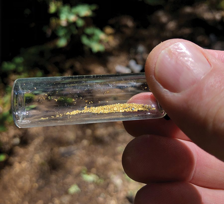
Today, we’ve brought Pia to the Tot Hill Farm Trailhead, the northernmost point of the Birkhead Mountain Wilderness Area, where she can roam free. Our playground is the 52,000-plus-acre Uwharrie National Forest that stretches into Montgomery, Randolph and Davidson counties. Under National Forest rules, Pia can run free. As can we. Cross-country trekking is allowed, as is horseback riding, ATV riding, camping, panning for gold, hunting and fishing — all, of course, with some reasonable restrictions. (You must “control” your pets.)
Our inner child kicks in as we cross Talbotts Branch. We pass the stone remains of a dam, and at the tippy top of Coolers Knob, our GPS says we’ve clocked 333 feet of vertical ascent in 1.2 miles. We pant. Pia pants.
We keep booking it, heading for Camp 5, one of a number of campsites established by Joe Moffitt. In 1972, he started his Uwharrie Trail Project, backed literally by troops of Boy Scouts. At the 3-mile mark, we hang a left and take the Camp 3 Trail, which is marked as the Coolers Knob Mountain Trail on some maps. This initiates a loop that will take us back to Coolers Knob.
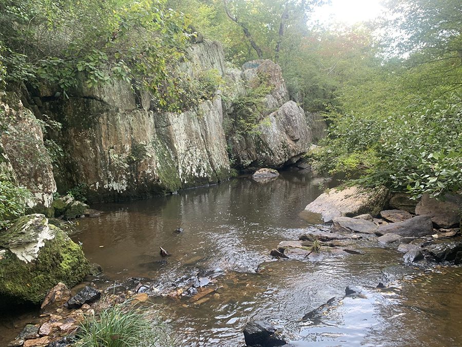
Serious hikers call this a lollipop trek because of its shape on the map. It’s one of the most magical hikes in the Uwharries. We descend to the inviting Camp 3 site, checking out an enclosed spring. Decades peel away and we’re soon frolicking knee-deep in a maze, aptly named fern valley. At 3.9 miles, we cross a cascading brook. A gentle waterfall is punctuated with islands of wildflowers.
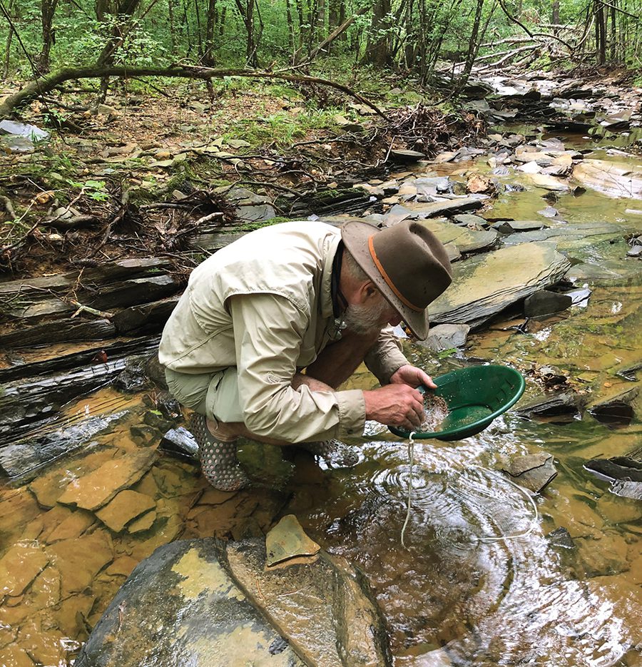
At 4 miles, we come to a series of open-pit gold mines, each of which Pia explores extensively. These are the remains of a gold mining era that began in 1799 when a 12-year-old found a 17-pound nugget of gold in a creek about 25 miles east of Charlotte. Farmers riddled their land with open pits and shafts like the ones that surround us. At one time, as many as 600 mines dotted the nine counties surrounding Montgomery County.
But the riches of the Uwharries are less tangible — its lush vegetation and wildlife, its wilderness, and its storied past. Though I hike for exercise and adventure, I’m always looking for something else — for the child who once roamed free without a care. And for the ties that bind us to the land and to those who inhabited it millennia before we did. Whether it’s the Moonshine Run Trail or the hike to Bingham’s Graveyard, the treasures of the Uwharrie Mountains always beckon.
Length: Our “lollipop” trek totaled 7.4 miles. If you just hiked to Camp 5 and back, it would be 6.4 miles.
Difficulty: More than moderately challenging with 607 feet of elevation gain
Don’t miss: The gold mines. You can visit them without making the loop by taking a left after 2 miles onto the Coolers Knob/Camp 3 trail. They’re about a mile down the trail.
Good to know: There’s not a sign on the road marking the Tot Hill Trailhead. Slow down and look for it as soon as you see the golf course.
Address: 3091 Tot Hill Farm Rd., Asheboro SP
Featured image courtesy AllTrails.